

When one thinks of stone circles, the likelihood is that Stonehenge and Avebury are the first that come to mind. Cumbria, however, is one of the most densely populated regions for these prehistoric marvels, and also contains some of the most complete stone circles in England.
Even today the purpose of these stones remains a mystery. Theories range from religious meeting places to the first astronomical observatories, although we prefer the rather more wacky explanations that local folklore often provides (see our full article here).
Regardless of their original purpose, what we do know about these ancient circles is that they were built during the late Neolithic and early Bronze ages, somewhere between 3,500BC and 1000BC.
‘The Big Three’
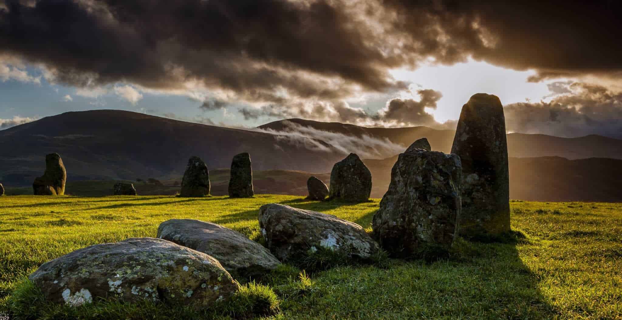
Perhaps the oldest remaining stone circle in England is at Castlerigg near Keswick, with 38 large stones standing up to 10 feet high. It is thought that this was originally an important site for prehistoric astronomers or early pagan rituals, as the stones are laid out in a solar alignment.
For visitors to the site, Castlerigg is often referred to as one of the most dramatic stone circles in the country as it is set against the backdrop of some of the highest peaks in the Lake District.
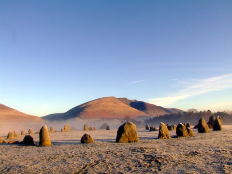
Castlerigg Stone Circle, photo copyright Michael Turner.
Originally consisting of around 60 stones, Swinside is a remarkably intact stone circle with 55 of the megalithic structures still remaining. A small gap between the stones acted as an entrance way, and is still visible on the south-eastern side of the site.
Although most archaeologists are in agreement that Swinside was originally built for ceremonial reasons, over the years there has been an abundance of local folklore about the circle. One of these beliefs state that it is impossible to actually count the stones, although a quick five minutes looking at Google Earth quickly put that rumour to rest!
Another popular folklore tale states that it was the Devil who was responsible for the stone formation. Legend has it that the local people of Swinside attempted to build a church on the site, but every night the Devil would scupper their plans by knocking it down and placing the stones in a circle.
A Google Maps aerial shot of Swinside Stone Circle
What a great name for a stone circle! ‘Meg’ was actually a local witch who was alive during the 1600s, and legend states that if you walk around the circle and count all of the stones correctly, and then put your ear to the largest stone called “Long Meg”, you will hear her whisper to you.
Long Meg and Her Daughers are actually just a single part of a much larger complex, with other structures and enclosures (most of which are now underground) dotted around the nearby vicinity. The smaller stone circle of Little Meg (which is actually the remains of a cairn) is one of these additional structures, and is located about 700 yards away from its larger sibling. If you visit Little Meg, be sure to keep an eye out for one of the stones which contains prehistoric markings.
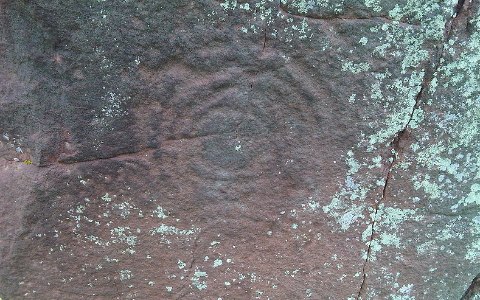
Prehistoric carvings on the Long Meg stone
Other Stone Circles in Cumbria
What makes Birkrigg so special is that it is one of only thirty concentric stone circles ever found in Britain. The inner ring consists of 12 stones, whilst the outer ring is in a slightly more ‘irregular’ pattern consisting of 20 stones.
Birkrigg is situated on the south Cumbrian coast, a region which was densely populated (in relative terms) during the Neolithic and Bronze ages.
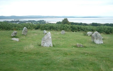
A photo of Birkrigg Stone Circle. Licensed under the Creative Commons Attribution-Share Alike 3.0 Unported license. Credit: Yohan euan o4
Situated around four miles from Cockermouth, Elva Plain is a stone circle which is best described as ‘blink and you’ll miss it”. The circle itself is situated on the slope of Elva Hill, and boasts some great views over the surrounding glens and peaks.
The tallest stone here is barely a metre tall, and under half of the original 30 stones still remain.
This small circle contains only 11 stones, but what it lacks in quantity it more than makes up for with views over the open moorland, distant peaks, and even the occasional glimpse of Scotland and the Isle of Man. Best of all, this is one of the least visited stone circles in Cumbria, so any visitors should have it all to themselves.
Unfortunately Blakely Rise has been recently reconstructed, with concrete holding the boulders in place.
Blakely Rise, as seen from the road
Excavated in 1900, the stones at Glassonby are just over a mile from the much larger Long Meg and Her Daughters circle, suggesting that this area was once populated by a relatively large Bronze Age community.
Just a word of note; apparently these stones are located on private ground, so any visits should be arranged with the local farmer.
The Gamelands circle is extremely large in circumference, and is in fact the largest in Cumbria. Unfortunately it is not the best preserved in the area, and all of the stones are now on their side (if, indeed, they were ever set upright).
Artefacts found in the area suggest that this was a relatively early structure, probably dating back to the later half of the Neolithic period. Unfortunately heavy farming at the turn of the century has meant that the some of the stones have been damaged, although the outline of the circle is still plainly visible.
Although the Victorians were responsible for some of our greatest accomplishments, the preservation of archaeology unfortunately wasn’t one of them, as can be seen by the almost laughable state of affairs with the Kemp Howe Stone Circle. In short, the Victorians built the West Coast Main Line Railway on top of it!
In its heyday, Kemp Howe would have been one of the impressive stone circles in England. It had a long avenue of stones leading to it, some of which are still standing to this day, and at the end of the avenue may have been either a large prehistoric settlement or a ‘mega-monument’.
An aerial photo of Kemp Howe, with the West Coast Main Line running through it!
This tiny stone circle consists of only 10 boulders, approximately 6 to 7 metres in diameter. Due to its small size, it is likely that Castlehowe Scar is the remains of a ring cairn, and that its smaller stones were either robbed or have been lost through farming.
In the winter, it is often possible to see the outline of other stone circles in the adjacent fields.
By now we’re almost getting spoilt by choice, but if you’re in the area of Crosby Ravensworth then a trip to the Oddendale stone circle won’t disappoint. This is another concentric ringed structure, well preserved and easy to access.
The stone circle at Gunerkeld has had its fair share of obstacles to contend with over its long and rather fortunate history. First the Victorians wanted to build the West Coast Main Line over it (as per the fate of the nearby Kemp Howe circle), and then the M6 motorway was built only a stones throw away. Added to the fact that many of its boulders have been robbed over the last three millennia, it’s amazing that Gunnerkeld stone circle still exists at all. Perhaps most astonishing of all, two of the boulders that made up the entrance way to this concentric circle are still upright, standing at a height of about a metre and a half each.
Mayburgh Henge is one of three prehistoric structures within earshot of each other, the other two being King Arthur’s Round Table Henge and Little Round Table Henge. No-one knows why these three henge’ were built so close to each other, or what the connection was between them. What we do know is that Mayburgh Henge would have played the role of an ancient amphitheatre, where hundreds of local onlookers would have witnessed ceremonies and rituals.
The seating area would have been on the huge circular bank which surrounds the last remaining standing stone. The bank was made up of millions of cobblestones brought in from the nearby River Eamont, and would have stood at a height of 8 – 10 metres. In the centre would have been four large standing stones (only one of which remains), whilst four more standing stones would have stood at the entrance to the henge.

A map of Mayburgh Henge and the surrounding prehistoric sites, circa 1770.
Of all of the stone circles in Cumbria, this is the one to miss. It is situated within a stones throw of the Sellafield Nuclear Reprocessing Plant, and the boulders themselves were toppled and buried by a disgruntled farmer in the early 1800s. Luckily a group of local school children in the 1940s decided to intervene and reassemble the stone circle, although any archaeological accuracy may well have been lost in the process!
Situated three hundred metres above sea level on a windswept fell lies Moor Divock, a group of prehistoric sites with stone circles, cairns, megaliths, and probably the remains of a bronze aged settlement. Although many of the ancient structures have been lost over the years, the main stone circle called The Cockpit is still relatively well preserved and well worth a visit.